
Nashoba
Conservation
Trust

Nashoba
Conservation
Trust
Gulf Brook
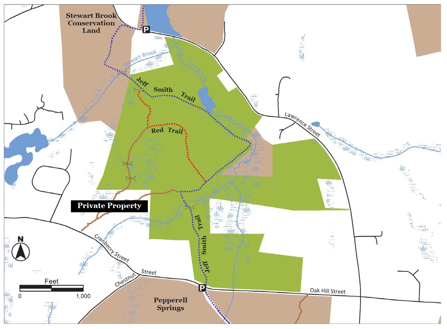
The 208-acre Gulf Brook Conservation Area provides important habitat for Saw Whet Owls, Wood Thrushes, otters, mink, and beavers. Hemlocks covered with lichens, mossy rocks and boulders, gigantic cinnamon ferns, and tall white pines are some of the natural wonders in these forests. Songbirds, herons, amphibians and turtles can be found in the beaver pond. Gulf
Brook abuts the Stewart Brook property.
Land Protection History
The Pepperell Water Division and Conservation Commission protected 193 acres to preserve the recharge area of a town well and the Gulf Brook watershed. NCT’s 12-acre Dermody and 2.7-acre Ames property abut the town lands in this conservation area. NCT acquired the Dermody property in 1978 and the Ames property in 1983. Both NCT parcels help safeguard an important town water supply while protecting both Stewart and Gulf Brook watershed areas and habitats.
Trail Description
The Jeff Smith Trail continues from the Pepperell Springs property into Gulf Brook Conservation Area. The trail passes through an Eastern hemlock forest and over several small streams that drain into Gulf Brook and a large beaver pond. At 0.37 miles the trail intersects with another trail originating from private property on Cranberry Street. Turn right and head east tothe beaver pond. The trail follows along the pond and Gulf Brook and then through a wetland of cinnamon ferns to the old Menshun’s Pond area. At approximately the 1.0 mile mark the trail divides: continue straight to follow the Jeff Smith Trail to the Stewart Brook Conservation Land; or turn left to follow the Red Trail (marked with red T.O.P markers) back to the parking area on Oak Hill. Please take note: portions of these trails are very wet year-round.
Trail Mileage
From the street trail head the Jeff Smith Trail to the Stewart Brook crossing is 1.35 miles. The loop trail combining the Jeff Smith and Red Trail is 2.0 miles in length. As can be seen on the map, two trails continue from conservation land on to private property. The bounds are not posted; therefore it is advised to avoid these trails.
Directions
From Pepperell Town Hall, go north onto Park St. north from Main St. about 1 mile until you reach a fork and take a left onto Oak Hill St. Go about 1.5 miles and look for the wooden conservation sign (above). There is a small parking areas across the street from the trail on Chestnut St. The GPS coordinates for the parking area are: Latitude 42.68533; Longitude -71.63252.
Click map to enlarge
All rights reserved. All content on this site property of Nashoba Conservation Trust.
Do not copy or reproduce in any form for any reason without written permission from Nashoba Conservation Trust.